







An evidence-based briefing on ice-rock avalanches, permafrost degradation, and compound hazard chains in the Hindu Kush Himalaya.
I. Introduction: A Paradigm Shift in Himalayan Hazard Science
For three decades, the dominant mental model of Himalayan disaster risk has centred on one image: a glacial lake, swollen by decades of ice melt, bursting through its earthen dam and sending a wall of water down a valley. That model – the Glacial Lake Outburst Flood, or GLOF – has shaped early warning investment, hazard mapping, and international funding across the Hindu Kush Himalaya (HKH) for a generation. But the catastrophic events of the past two years have forced scientists to confront an uncomfortable reality: some of the deadliest high-altitude disasters now begin not with a lake, but with the mountain itself giving way.
A. Beyond Lake Breaches: From GLOF-Centric Models to Slope Destabilization
Historically, hazard assessment protocols across Nepal, Bhutan, and the Tibetan Plateau have prioritized glacial lake inventories – mapping lake area, estimating moraine dam stability, and modelling breach scenarios. This approach made sense when the primary driver of concern was glacier retreat creating and enlarging proglacial lakes. Research bodies such as the International Centre for Integrated Mountain Development (ICIMOD) have long documented how thawing permafrost destabilizes the moraine and debris-covered slopes that dam these lakes, and a three-fold increase in GLOF risk across the HKH has been projected by the end of the century, with researchers warning of a coming ‘peak GLOF risk’ period around 2050.
Yet a newer and less understood category of hazard is now emerging alongside – and sometimes independently of – glacial lakes: structural bedrock failure. In these events, the rock mass anchoring a hanging glacier in place simply fractures and gives way, carrying millions of tonnes of ice and stone down the mountainside with no lake, and often no warning sign visible from the surface, involved at all. This is the essence of the paradigm shift this article explores: hazard science built for slow-forming lakes is not built for slopes that fail from within.
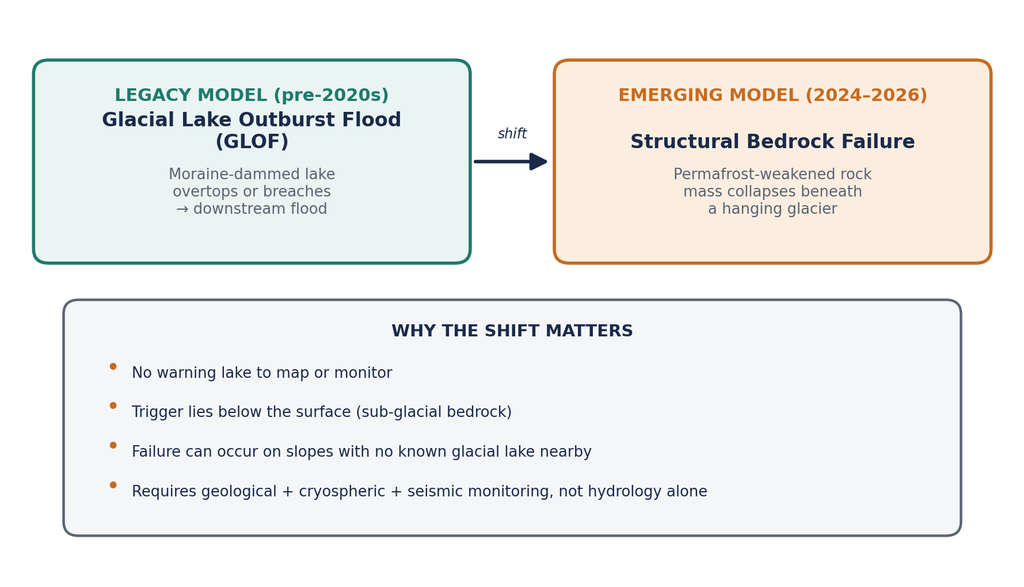
Figure 1: The shift from lake-centric GLOF models to structural bedrock failure as a distinct high-altitude hazard pathway.
B. Case Study Analysis: Langtang Lirung (2026) and Thame Valley (2024)
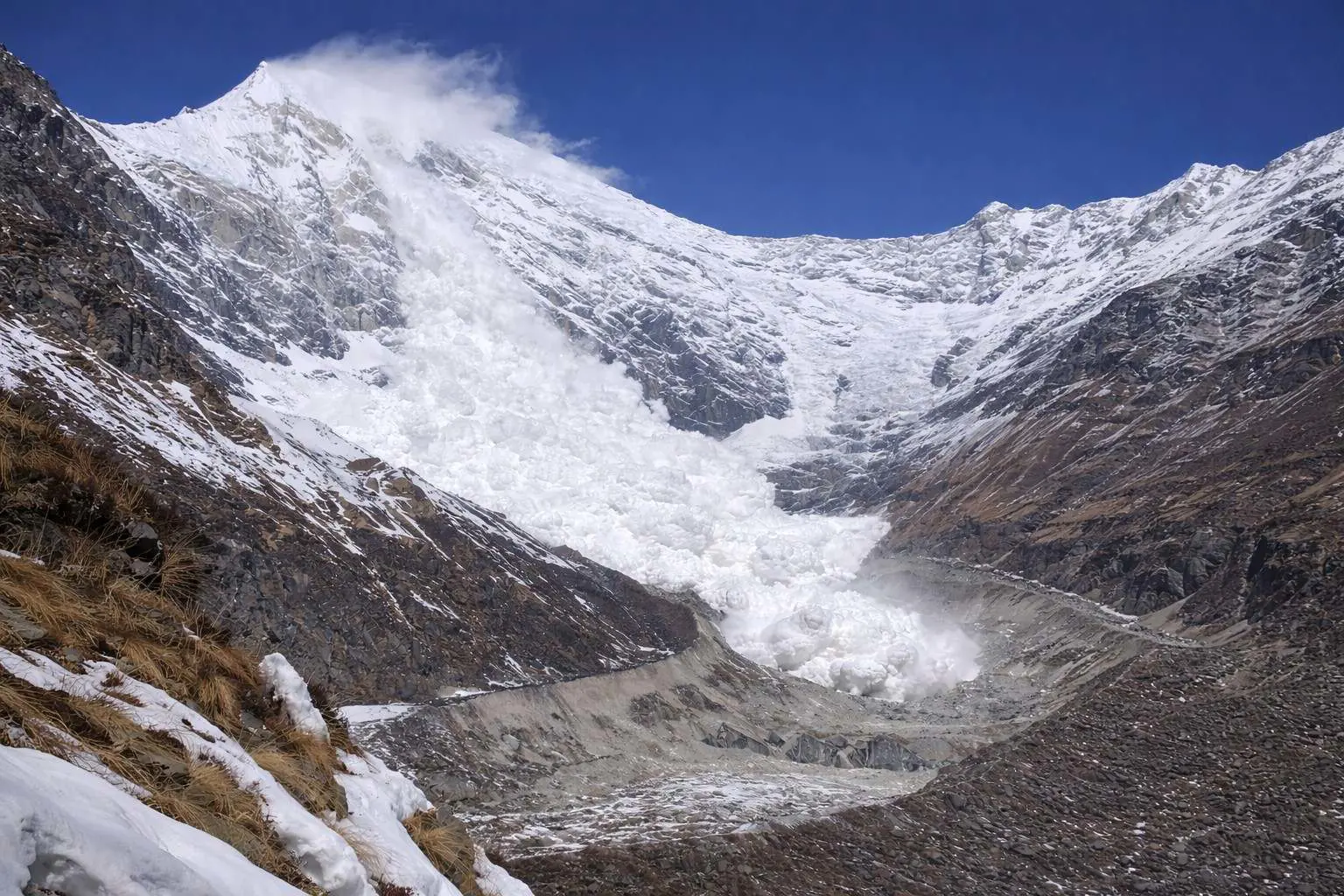
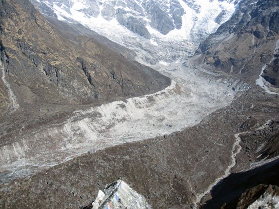
Two recent events illustrate the spectrum of cryosphere-linked collapse now confronting the region. On 26 August 2026, at roughly 10:50 a.m. local time, a massive section of bedrock and glacier ice broke away from the north slope of Langtang Lirung, near the Nepal–Tibet border, at an elevation of approximately 5,200 metres. Satellite analysis by geomorphologists reviewing imagery in the days that followed confirmed that the bedrock beneath the glacier – not merely the ice itself – had failed, taking a massive chunk of glacier down with it. The debris mass reportedly reached speeds of around 167 kilometres per hour, slammed into the Lende (Lendey) Khola, a tributary of the Bhotekoshi and Trishuli river system, and briefly dammed the gorge before the barrier burst. The resulting surge travelled roughly 22 kilometres in about seven minutes, devastating villages, roads, bridges, and the Gyirong border checkpoint, with more than a thousand people killed or reported missing across Nepal and the Tibet Autonomous Region.
The event registered on seismic networks worldwide: the United States Geological Survey (USGS) recorded a signal equivalent to magnitude Ms 5.2, while Germany’s GFZ Helmholtz Centre for Geosciences logged a consistent Mw 5.7 signature – both consistent with a large landslide rather than a tectonic earthquake. Satellite deformation analysis later revealed that the glacier north of Langtang Lirung had been creeping at around 10 millimetres per month between January and August 2026, with the rate of movement accelerating markedly in the weeks before collapse – a precursor signal that, had it been monitored continuously, might have offered a warning window. Notably, researchers investigating the disaster have been explicit that this was not a GLOF; it was a multi-hazard cascade beginning with combined ice-and-bedrock failure.
Two years earlier, on 16 August 2024, a different but related mechanism struck the Everest region. A rock avalanche fell into an upper glacial lake in the headwaters of the Thame Valley at about 4,900 metres, generating a displacement wave that overtopped and breached the lake’s moraine-and-bedrock dam. That breach then triggered the failure of a second lake downstream – a cascading GLOF that released a combined volume of roughly 459,000 cubic metres of water, reaching Thame village within 22 to 25 minutes and destroying homes, schools, health facilities, and bridges while displacing 135 people. ICIMOD’s subsequent field investigation, conducted with Nepal’s National Disaster Risk Reduction and Management Authority, confirmed that the upper lake had formed only in the late 2000s and had expanded rapidly – underscoring how small, young, seemingly low-priority lakes can still produce high-energy, cascading disasters.
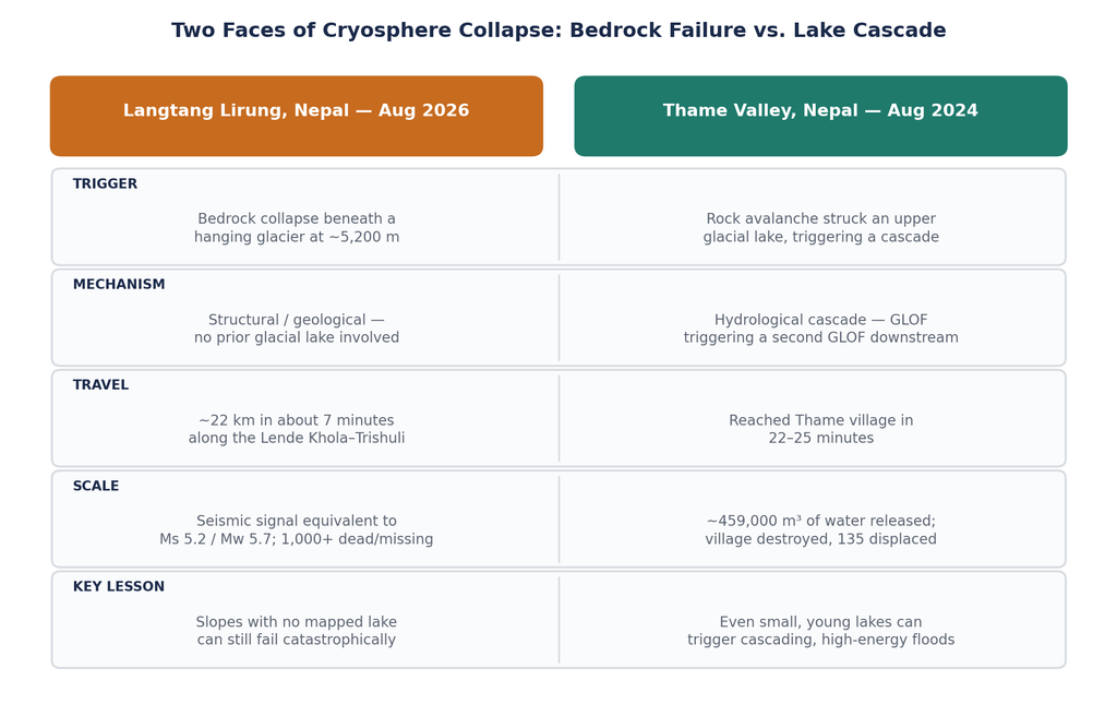
Figure 2: Comparing the structural (Langtang Lirung, 2026) and hydrological-cascade (Thame Valley, 2024) failure pathways.
C. Research Objectives: Toward a Multi-Hazard Assessment Framework
Taken together, these cases argue for a fundamental broadening of how hazard assessment is conducted above 5,000 metres in elevation. Rather than treating glacial lakes as the primary unit of risk analysis, an integrated framework must simultaneously evaluate permafrost thermal state, bedrock jointing and fracture density, glacier-bed coupling, seismic micro-activity, and downstream sediment transport capacity. The remainder of this article works through the geophysical drivers of these failures, the cascading hazard chains they set in motion, the monitoring technologies capable of catching them before they happen, and the policy and engineering responses now being discussed across the region.
II. Geophysical Drivers of Bedrock and Glacier Failure
What makes a mountainside that has stood for millions of years suddenly let go? The answer lies in a slow accumulation of structural weaknesses, most of them invisible from the surface, that reach a tipping point under the combined pressure of a warming climate and gravity. Three interlinked processes are central to current scientific understanding: permafrost thaw, pore-water pressure build-up, and frictional heating during the failure itself.
A. Permafrost Thaw and Hydrothermal Shear
Mountain permafrost – ground that remains frozen for two or more consecutive years – does more than sit passively beneath high-altitude terrain. According to ICIMOD’s cryosphere research programme, permafrost actively stabilizes rock slopes, moraines, and debris-covered terrain by adding cohesion between fractured rock blocks and by preventing the build-up of hydrostatic pressure within joints. As global and regional temperatures rise, this frozen ‘glue’ is degrading: the active layer (the surface zone that freezes and thaws seasonally) is deepening, and the lower elevation limit of permafrost is retreating upslope.
Laboratory research conducted at ETH Zurich’s Rock Physics and Mechanics Lab, cited in ICIMOD’s regional cryosphere forums, has found that rock stability decreases sharply once fracture temperatures move into the narrow band between −1°C and 0°C – precisely the thermal window that a warming climate is pushing more high-altitude rock into for longer periods each year. On slopes steeper than roughly 30 degrees sitting within this temperature range, researchers characterize conditions as inherently precarious. This is the essence of what is now widely termed hydrothermal shear: as ice within rock joints transitions from solid to liquid, the frictional resistance holding fractured rock blocks together drops, and shear failure along pre-existing joints and faults becomes increasingly likely.
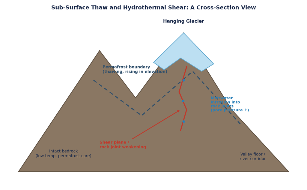
Figure 3: Cross-section schematic of permafrost degradation and meltwater-driven shear weakening beneath a hanging glacier.
B. Cryostatic and Pore Pressure Dynamics
A second, closely related driver involves water itself acting as a mechanical wedge. As surface and englacial meltwater increases with warmer summers, it finds its way into bedrock fissures and fractures beneath and around hanging glaciers. Once trapped within a fracture network – particularly one where the exit pathways are still partially blocked by residual ice – this meltwater generates elevated pore-water pressure. That pressure pushes outward against the fracture walls, effectively reducing the normal stress holding the rock mass together and lowering its shear strength, in much the same way that pore pressure build-up drives slope failures in unfrozen terrain worldwide.
In the case of the 2026 Langtang Lirung collapse, the summer preceding the event brought some of the highest recorded temperatures across this part of the Himalaya. Geologists reviewing the disaster in its aftermath have noted that the resulting meltwater plausibly entered rock fractures and contributed to weakening that helped trigger the eventual collapse – although, as researchers have been careful to caution, the precise causal chain for any single event of this kind remains difficult to establish with certainty given the sub-surface and largely invisible nature of the process.
C. Frictional Heating and Phase Transformation
The third driver operates not before failure, but during it. When a multi-million-tonne mass of rock and ice detaches from an elevation of 5,000 metres or higher and begins its descent, gravitational potential energy converts into kinetic energy – and, critically, into heat. As the descending mass grinds against the valley walls and against itself across a vertical drop that can exceed several thousand metres, frictional heating becomes intense enough to begin melting the ice components of the debris mass in transit.
This phase transformation – solid ice becoming liquid water mid-flow – fundamentally changes the physical behaviour of the moving mass. What begins as a rock-and-ice avalanche increasingly behaves as a hyper-concentrated slurry: a fast-moving, high-density mixture of water, fine sediment, and boulders capable of travelling extraordinary distances at high velocity along river corridors, entraining additional sediment and debris as it goes. This transformation from solid avalanche to fluidized debris flow is a key reason these events can travel tens of kilometres from their source in a matter of minutes.
III. Cascading Hazard Mechanisms and Downstream Impacts
Perhaps the most dangerous feature of structural bedrock failure is not the initial collapse itself, but the chain of secondary hazards it sets off downstream. Modern disaster risk literature increasingly frames these events as compound hazard chains – sequences in which each stage amplifies or transforms the hazard delivered to communities below.
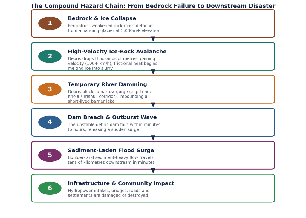
Figure 4: The six-stage compound hazard chain observed in the 2026 Langtang Lirung event, from initial bedrock collapse to downstream community impact.
A. River Damming and Outburst Waves
Steep Himalayan gorges such as the Lende Khola and the wider Trishuli corridor act as natural funnels for descending debris. When a large volume of rock, ice, and sediment enters a narrow valley, it can rapidly choke the river channel, forming a debris dam and impounding water behind it within minutes. These landslide dams are inherently unstable – built from loose, unconsolidated material rather than engineered fill – and in the Langtang Lirung event, the barrier formed at the Lende Khola failed and released its impounded water not long after forming, generating a secondary outburst wave that added to the destructive power of the primary debris surge. This dam-then-breach sequence is a recurring signature of large-scale slope failures in steep alpine terrain and is a central reason a single collapse event can produce two distinct pulses of flooding downstream.
B. Sediment Load and Infrastructure Destabilization
The debris surges generated by these events are not simply floodwater; they are dense, boulder-heavy slurries capable of overwhelming engineered infrastructure designed for ordinary monsoon flows. Run-of-river hydroelectric stations – a mainstay of Nepal’s energy infrastructure in precisely these steep valley corridors – are acutely exposed, since their intake structures and headrace tunnels sit directly in the river channel. Sediment-choked surges can bury intakes, abrade turbine components, and, in severe cases, destroy powerhouses outright, as was reported along the Bhotekoshi-Trishuli corridor following the 2026 event. Roads, suspension bridges, and border trade infrastructure – including the Gyirong crossing between Nepal and the Tibet Autonomous Region – face similar exposure, with rebuilding timelines often stretching into years given the remoteness and difficult terrain of the affected valleys.
C. Socio-Economic Vulnerability
Beyond physical infrastructure, these compound hazard chains inflict long-tail social and economic damage on mountain communities that are already among the most marginalized in South Asia. Displacement is immediate and often prolonged: villages built along valley floors and river terraces – the only flat, cultivable land available in this terrain – are frequently the first structures in the debris path. Cross-border trade hubs, vital to the local economies of both Nepal and the Tibet Autonomous Region, can be severed for extended periods, disrupting the flow of goods and remittance-linked income. And because these valleys often depend heavily on trekking tourism (as in the Everest and Langtang regions), a single event can simultaneously destroy homes, livelihoods, and the tourism infrastructure communities rely on to rebuild – a compounding of vulnerability that purely engineering-focused hazard assessments tend to underweight.
IV. Monitoring Gaps and Technological Paradigms
If structural bedrock failure is fundamentally different from lake-breach GLOFs, then the monitoring infrastructure built to catch the latter is not automatically equipped to catch the former. This section examines where current monitoring falls short, and what technologies offer a path forward.
A. Limitations of Optical Satellite Imagery
The default tool for post-disaster analysis across the Himalaya remains optical satellite imagery – platforms such as Landsat, Sentinel-2, and commercial providers like Planet and Vantor. These have proven invaluable after the fact: geomorphologists reviewing imagery in the days following the Langtang Lirung collapse were able to confirm that bedrock beneath the glacier, not just glacier ice, had failed, and were able to trace the debris path and dam formation with considerable precision. But optical imagery has a fundamental structural limitation: it can only see what has already changed on the surface. It cannot detect the growth of a fracture network deep within a rock mass, nor the gradual warming of a permafrost layer buried metres below the surface – the very processes that precede failure. Cloud cover, seasonal snow, and revisit gaps of days between satellite passes further limit its use as a predictive, rather than purely diagnostic, tool.
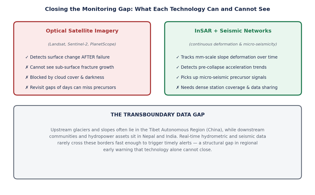
Figure 5: Complementary strengths and blind spots of optical satellite imagery versus continuous InSAR and seismic monitoring.
B. Synthetic Aperture Radar (InSAR) and Seismic Networks
Two technologies now offer a genuinely predictive alternative. Interferometric Synthetic Aperture Radar (InSAR) can detect millimetre-scale ground deformation over time by comparing successive radar images of the same slope, regardless of cloud cover or daylight. Applied continuously to known high-risk slopes, InSAR can reveal the kind of pre-collapse creep documented at Langtang Lirung, where satellite deformation analysis showed the glacier moving at around 10 millimetres per month before accelerating sharply in the weeks ahead of the August 2026 collapse – precisely the kind of accelerating-creep signature that continuous InSAR monitoring is designed to flag.
Complementing this, dense seismic networks can pick up the micro-seismic signatures – small tremors and acoustic emissions generated by fracturing rock – that often precede major slope failures by hours to days. In the aftermath of the Langtang Lirung event, global seismic networks operated by the USGS and Germany’s GFZ Helmholtz Centre for Geosciences were able to characterize the collapse’s magnitude and mechanism after the fact using long-period seismic wave analysis; a denser regional network, purpose-built for pre-collapse detection rather than post-event characterization, could plausibly shift this capability from forensic to predictive use.
C. Transboundary Data-Sharing Protocols
A persistent structural obstacle undercuts even the best monitoring technology: many of the glaciers and slopes generating these hazards sit in the Tibet Autonomous Region of China, upstream of communities and infrastructure in Nepal and India. Hydrometric, seismic, and satellite deformation data generated on one side of this politically sensitive border does not always flow efficiently, or in real time, to disaster management authorities on the other. This is not merely a technical gap but a governance one, and closing it will require dedicated transboundary data-sharing protocols – a theme increasingly emphasized in ICIMOD’s regional dialogues on permafrost and cryosphere hazard monitoring across the Hindu Kush Himalaya.
V. Engineering Resilience and Policy Recommendations
Closing the monitoring gap is necessary but not sufficient. A resilient response to this new generation of high-altitude hazards requires parallel investment in early warning infrastructure, physical engineering adaptation, and international climate finance mechanisms capable of funding all of the above in some of the world’s most remote and least-resourced terrain.
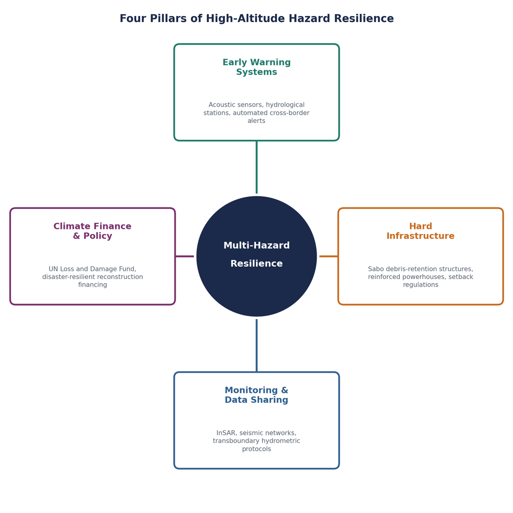
Figure 6: A four-pillar framework for high-altitude hazard resilience, integrating monitoring, engineering, early warning, and climate finance.
A. Next-Generation Early Warning Systems (EWS)
Effective early warning for compound hazard chains needs to integrate multiple sensor types into a single automated alert pipeline: acoustic and seismic sensors placed on or near known unstable slopes to detect precursor fracturing; downstream hydrological gauging stations able to detect the sudden rise in river stage that signals a debris dam has already formed or breached; and automated, low-latency alert systems capable of pushing warnings to downstream communities within minutes rather than hours. Given that the Langtang Lirung debris surge covered 22 kilometres in only about seven minutes, warning systems for this class of hazard must be measured in minutes of lead time, not hours – placing a premium on sensor placement as close to the source as possible and on alert systems that do not depend on manual verification steps that cost precious time.
B. Hard Infrastructure Adaptation
Engineering adaptation complements early warning by reducing the destructive potential of a hazard that does occur. Sabo debris-retention structures – a design approach refined extensively in Japan for exactly this kind of sediment-laden mountain flow – use a staged series of check dams and retention basins to slow and trap debris before it reaches populated valley floors, reducing both peak discharge and boulder impact energy downstream. Powerhouses and intake structures for run-of-river hydropower plants in high-risk corridors increasingly need to be designed, or retrofitted, with reinforced, debris-resistant intakes and sacrificial sediment-flushing systems, rather than conventional designs calibrated only for ordinary monsoon sediment loads. Finally, updated setback regulations – legally mandated buffer distances between river channels and permanent settlements or critical infrastructure – offer a comparatively low-cost, high-impact way to reduce exposure along alpine river channels prone to this kind of surge.
C. Climate Justice and International Financing
The mountain communities bearing the brunt of these disasters have contributed negligibly to the greenhouse gas emissions driving the permafrost degradation now destabilizing their homeland. This asymmetry is at the heart of the climate justice case for directing international financing toward high-altitude hazard monitoring and disaster-resilient reconstruction in the Hindu Kush Himalaya. Mechanisms such as the United Nations’ Loss and Damage Fund, established to help vulnerable nations cope with climate impacts they did little to cause, represent one plausible channel for financing the kind of dense InSAR, seismic, and hydrometric monitoring networks – plus the Sabo structures and reinforced infrastructure discussed above – that current national budgets in Nepal and neighbouring countries are unlikely to fund alone. Regional cooperation bodies such as ICIMOD, which already coordinate cryosphere research across the eight HKH countries, are positioned to serve as technical intermediaries channelling such financing into the ground-based monitoring networks the region currently lacks.
VI. Conclusion
A. Synthesis: How Bedrock Failure Changes Cryosphere Risk Management
The events at Langtang Lirung in 2026 and Thame Valley in 2024 are not isolated anomalies; they are early signals of a broader shift in the character of high-altitude hazard in a warming Hindu Kush Himalaya. ICIMOD has reported that glacier ice-loss rates across the region have roughly doubled since 2000, and the same warming trend driving that ice loss is simultaneously degrading the permafrost that has, for millennia, held steep alpine bedrock in place. The result is a hazard landscape no longer adequately captured by lake-inventory-based GLOF models alone. Structural bedrock failure, sub-surface thaw, and the compound hazard chains they trigger demand their own dedicated place within regional risk assessment frameworks – one built on continuous geophysical monitoring rather than periodic surface observation.
B. Future Outlook: Toward Integrated Himalayan Resilience
No single discipline can manage this risk alone. Glaciologists, structural geologists, seismologists, hydrologists, engineers, and policymakers across national borders will need to work from a shared, continuously updated picture of which slopes are moving, which permafrost zones are warming fastest, and which downstream communities and assets sit in the path of a potential failure. The urgency is not abstract: as warming continues to push mountain permafrost past the narrow thermal threshold at which rock stability collapses, the frequency of these structural failures is likely to rise before it falls. Building the transboundary monitoring networks, early warning systems, and climate financing pipelines described in this article is not a future project – it is an immediate one, and the mountain communities of the Hindu Kush Himalaya cannot afford to wait for the next collapse to prove the point.
References and Sources
This article draws on peer-reviewed research, official scientific institutions, and verified news reporting current as of September 2026.
1. Down To Earth – “When Rock Flows Like a River”: geological analysis of the 2026 Langtang Lirung ice-rock avalanche. https://www.downtoearth.org.in/natural-disasters/when-rock-flows-like-a-river
2. Phys.org – Satellite imagery analysis confirming bedrock collapse beneath the Langtang Lirung glacier, August 2026. https://phys.org/news/2026-08-satellite-images-bedrock-glacier-collapsed.html
3. AntarcticGlaciers.org – Early scientific analysis of the August 2026 Nepal–Tibet floods and glacier detachment. https://www.antarcticglaciers.org/2026/08/august-2026-nepal-tibet-floods/
4. Encyclopaedia Britannica – “Nepal floods of 2026”: overview of the glacier collapse, timeline, and impacts. https://www.britannica.com/event/Nepal-floods-of-2026
5. Wikipedia – “2026 Nepal–Tibet floods”: seismic data (USGS, GFZ Helmholtz Centre), casualty figures, and glacier movement analysis. https://en.wikipedia.org/wiki/2026_Nepal_floods
6. Wikipedia – “Langtang Lirung”: mountain profile including the 2015 and 2026 glacier collapse events. https://en.wikipedia.org/wiki/Langtang_Lirung
7. Natural Hazards and Earth System Sciences (NHESS) – Khadka et al., “The 2024 cascading glacial lake outburst flood in the Thame Valley of Everest region, Nepal: process, impacts and implications.” https://nhess.copernicus.org/articles/26/4131/2026/
8. ICIMOD – “Everest region a hotspot of cryosphere-linked hazards”: findings from ICIMOD’s field study on the 2024 Thame flood. https://www.icimod.org/press-release/everest-region-a-hotspot-of-cryosphere-linked-hazards-icimods-new-study-on-nepals-2024-thame-flood-confirms/
9. PreventionWeb / ICIMOD & NDRRMA – “Thame Valley Glacial Lake Outburst Flood 2024: Causes, Impacts and Future Risks.” https://www.preventionweb.net/publication/documents-and-publications/thame-valley-glacial-lake-outburst-flood-2024-causes-impacts
10. Wikipedia – “2024 Thame flood”: summary of the cascading GLOF event in Solukhumbu District, Nepal. https://en.wikipedia.org/wiki/2024_Thame_flood
11. ICIMOD – “GLOF from Thyanbo glacial lake sweeps away Thame Village”: initial press release and regional GLOF risk projections. https://www.icimod.org/press-release/glof-from-thyanbo-glacial-lake-sweeps-away-thame-village/
12. ICIMOD – “Permafrost”: overview of permafrost’s role in stabilizing Hindu Kush Himalayan rock slopes and moraines. https://www.icimod.org/mountain/permafrost/
13. ICIMOD – Proceedings, “Developing a Strategy to Monitor Permafrost Changes in the Hindu Kush Himalaya,” including ETH Zurich rock-stability threshold findings. https://www.icimod.org/proceedings/developing-a-strategy-to-monitor-permafrost-changes-in-the-hindu-kush-himalaya/
14. npj Natural Hazards (Nature) – Machine-learning-based permafrost distribution and mass-movement cascade modelling in the western Himalaya. https://www.nature.com/articles/s44304-026-00217-4
15. Unofficial Networks – Analysis of the Langtang Lirung glacier collapse citing ICIMOD data on accelerating Hindu Kush Himalayan glacier ice loss. https://unofficialnetworks.com/2026/08/27/nepal-tibet-glacier-collapse-flood/
16. ICIMOD – “Monitoring and Understanding Permafrost in Humla, Nepal”: field research on rock glaciers as permafrost indicators. https://www.icimod.org/monitoring-and-understanding-permafrost-in-humla-nepal/