








1. Introduction
1.1 The Hydropower Expansion Boom in Nepal’s Glaciated Basins
Nepal has staked its economic future on hydropower. With an estimated theoretical potential exceeding 80,000 MW drawn from its snow- and glacier-fed rivers, the country has spent the past decade racing to build run-of-river (RoR) plants along the Trishuli, Bhote Koshi, Tama Koshi, and Budhi Gandaki corridors – river systems whose headwaters lie inside the rapidly changing cryosphere of the Hindu Kush Himalaya (HKH). Run-of-river design, which relies on a low diversion weir and headrace tunnel rather than a large storage reservoir, was favoured for its lower upfront capital cost, faster construction timeline, and reduced submergence footprint. The Trishuli corridor northwest of Kathmandu became emblematic of this boom: a dense cascade of operating and under-construction plants – Trishuli 3A, Trishuli 3B, Upper Trishuli 1, Rasuwagadhi, Sanjen, Chilime, and Mailung Khola among them – packed into a narrow, glacially carved valley.
This concentration of energy infrastructure in a single high-gradient, glacially influenced catchment was, in retrospect, a geomorphic wager. Himalayan valleys are geologically young, tectonically active, and mantled with loose glacial till and paraglacial sediment left behind by retreating ice – material that is inherently unstable and primed to mobilise as debris flow when triggered by intense rainfall, glacial lake outburst floods (GLOFs), or landslide-dammed lake breaches. Hydropower planning across the region has historically applied design-flood standards calibrated to twentieth-century hydrological records, records that increasingly fail to capture the compound, cascading hazards produced by a warming cryosphere.
1.2 Systemic Grid Failure: Multi-Project Knockouts
On the morning of 26 August 2026, a catastrophic outburst originating from a blocked river channel on the Tibetan side of the border sent a wall of water, mud, and boulders down the Bhote Koshi River into Nepal’s Rasuwa district, overwhelming the Trishuli River for roughly seventy kilometres downstream. Wikipedia’s consolidated timeline of the event, drawing on Nepali government and international media reporting, describes the flood destroying the Gyirong border checkpoint and sweeping through dozens of settlements before cascading through the Trishuli hydropower corridor.
The Nepal Electricity Authority’s preliminary damage assessment – later folded into the government’s Rapid Damage and Needs Assessment (RDNA) – found that thirteen hydropower projects with a combined capacity of roughly 759 MW, together with five solar plants totalling 24 MW, had been damaged or destroyed. Combined, that is a loss of approximately 783 MW of generation capacity in a single event, concentrated in one river corridor. [9,10]
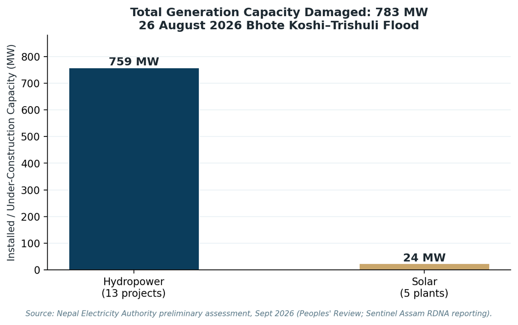
Figure 1. Generation capacity damaged or destroyed by the 26 August 2026 Bhote Koshi–Trishuli flood, split between operating hydropower, projects under construction, and solar assets. Sources: Nepal Electricity Authority preliminary assessment; Rapid Damage and Needs Assessment (RDNA), September 2026.
The human cost dwarfs even this substantial economic loss. As search-and-rescue operations continued into September, Nepal’s Ministry of Foreign Affairs and National Disaster Risk Reduction and Management Authority reported the confirmed death toll climbing past 1,380, with several thousand people – including hundreds of foreign nationals and roughly 900 hydropower-project workers – still unaccounted for. Rescue teams spent weeks pumping air into flooded tunnels at Upper Trishuli 3A and Upper Trishuli 1 in an effort to reach workers trapped underground, occasionally succeeding in extracting survivors alive more than a week after the flood struck. [1,3,4,8]
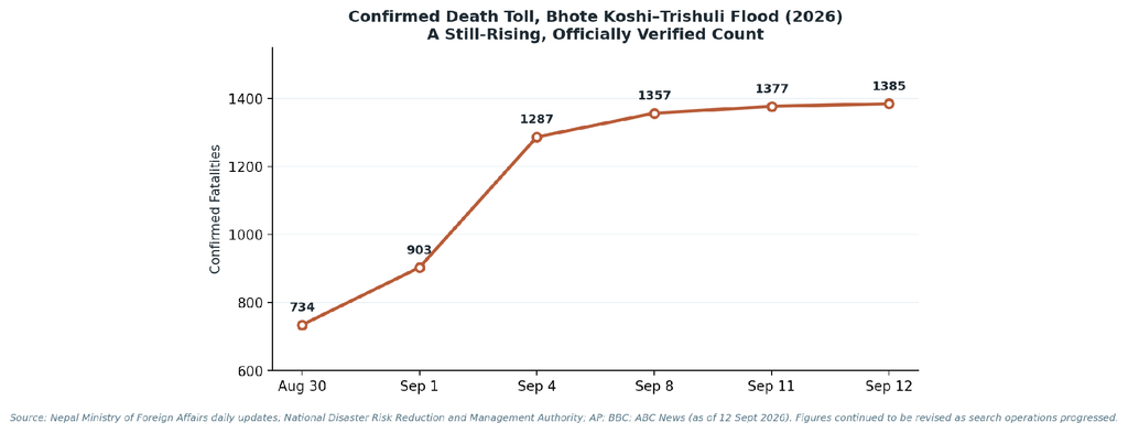
Figure 2. Confirmed fatalities from the Bhote Koshi–Trishuli flood continued to rise for over two weeks as search and verification work progressed. Sources: Nepal Ministry of Foreign Affairs daily updates; NDRRMA; AP; BBC; ABC News.
1.3 Scope of Research: Realigning Energy Security with Mountain Geomorphology
This paper treats the 2026 Bhote Koshi–Trishuli disaster as a case study in a broader, structural problem: the mismatch between conventional hydropower engineering standards and the geomorphic reality of a rapidly deglaciating mountain range. Rather than treat the flood as an unforeseeable ‘black swan,’ the analysis that follows examines the specific failure mechanisms – sediment transport, hydro-abrasive erosion, and tunnel inundation – that conventional design codes systematically under-anticipate in high-altitude glacial basins. It then evaluates a suite of engineering and policy interventions capable of closing that gap, framed collectively as Cryosphere-Resilient Energy Engineering: an approach that treats accelerating glacial melt, permafrost thaw, and sediment supply as first-order design inputs rather than externalities.
2. Anatomy of Infrastructure Failure under Cascading Debris Flows
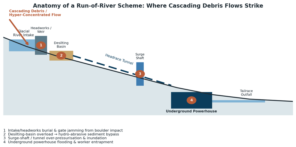
Figure 3. A typical run-of-river scheme and its principal points of failure under a cascading debris flow, from intake burial through to underground powerhouse inundation.
2.1 Structural Impact of Hyper-Concentrated Flows on Dam Intakes & Headworks
Conventional RoR headworks are engineered around a design flood computed from decades of historical streamflow records, typically expressed as a probable maximum flood (PMF) or a flood of a given return period. That approach implicitly assumes the flood is composed mostly of water. A cascading debris flow is a fundamentally different hydraulic phenomenon: a hyper-concentrated slurry of water, sand, gravel, and boulders, sometimes exceeding sediment concentrations of 60–80% by volume, moving with the density and impact force of wet concrete rather than river water. Such flows generate dynamic impact loads on trash racks, intake gates, and weir structures many times greater than the hydrostatic and hydrodynamic forces used in standard design calculations, and can bury an intake under metres of debris within minutes. Once an intake structure is buried or its gates jammed by boulder impact, the plant is off-line regardless of whether the powerhouse itself survives intact.
2.2 Hydro-Abrasive Sediment Erosion and Turbine Destruction
Even outside catastrophic debris-flow events, Himalayan rivers carry an exceptionally high background sediment load rich in quartz and other hard minerals, a legacy of the region’s active tectonic uplift and glacial erosion. Long-running case studies of Nepali plants such as Jhimruk and Khimti have documented severe hydro-abrasive wear on turbine blades, guide vanes, and facing plates within months of commissioning – far faster than designers anticipated – because desilting basins sized to trap coarse sand still pass large volumes of fine, highly abrasive particles into the turbine. [15,16]
Research on the Budhi Gandaki–Trishuli system has shown that the finer size fractions of suspended sediment are often more angular and mineralogically abrasive than coarser grains, meaning the very particles that desilting chambers struggle most to remove are also the most damaging to turbine runners. Studies on Pelton and Francis units elsewhere in the Himalayan region have measured efficiency losses of over one percent from erosion alone within a single monsoon season, alongside costly unplanned outages for bucket and nozzle replacement. During a hyper-concentrated debris event, this chronic abrasion problem is compressed into a single acute failure: sediment concentrations spike far beyond any desilting basin’s design capacity, and turbines, penstocks, and tunnel linings can suffer catastrophic material loss within hours.
2.3 Subsurface Inundation: Tunnel Trapping and Underground Powerhouse Vulnerabilities
The single most consequential design choice in modern Himalayan hydropower – locating the powerhouse underground, at the end of a long headrace tunnel, to protect it from surface hazards and reduce the visual and land-use footprint – became, in the 2026 disaster, the mechanism of mass casualty. When floodwater and debris overwhelmed the intake and surge shaft faster than tunnel drainage and ventilation systems could respond, workers stationed in underground powerhouses and access tunnels at Upper Trishuli 3A and Upper Trishuli 1 had little warning and even less means of escape before the tunnels flooded. Kulman Ghising, former Managing Director of the Nepal Electricity Authority, described the event as the most severe disaster in the history of the country’s hydropower sector and called for a fundamental review of powerhouse access design, emergency egress, and remote-operation protocols so that personnel are not required to remain underground during high-risk flood windows. [4]
3. Case Study Analysis: 2026 Trishuli Corridor Outburst
3.1 Damage Assessment: Generation Loss & Financial Reckoning
Nepal’s National Planning Commission and National Disaster Risk Reduction and Management Authority jointly produced a Rapid Damage and Needs Assessment (RDNA) in the weeks following the flood, estimating total national reconstruction needs at approximately NPR 723 billion (roughly US$4.74 billion), of which infrastructure accounted for about 75 percent of the total. Restoration of energy generation and power-grid systems alone was costed at NPR 390.6 billion (about US$2.56 billion). By mid-September, as the government appealed to international partners to treat the disaster as a shared climate responsibility, Nepali officials were citing recovery needs approaching US$7 billion. [6,9]
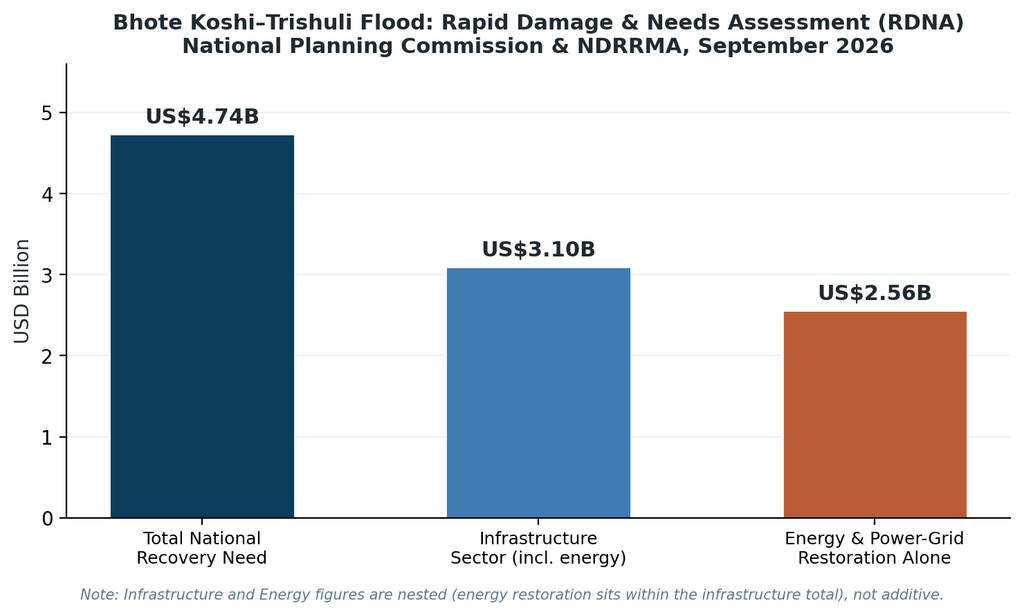
Figure 4. Reconstruction and recovery needs identified in Nepal’s Rapid Damage and Needs Assessment (RDNA), September 2026. Energy and power-grid restoration costs sit within the wider infrastructure-sector total.
Separately, an independent estimate compiled from developers’ financial statements by the Independent Power Producers’ Association, Nepal (IPPAN) put the combined construction value of the thirteen damaged projects at roughly NPR 145 billion, underlining that the destruction reached well beyond publicly owned assets into privately financed independent power projects – many financed through domestic bank loans that are now non-performing, with consequences for the wider banking sector.
3.2 Failure Mechanisms of Existing Flood Mitigation Barriers
Post-disaster reporting indicates that existing flood-protection measures along the corridor – embankments, gabion revetments, and localised check structures – were designed for conventional monsoon flood hydrology, not for a hyper-concentrated outburst flow originating from a blocked channel dozens of kilometres upstream across an international border. Several accounts describe a temporary barrier lake forming where the initial flood blocked the river channel, with hydrologists later warning of a secondary outburst risk as that lake continued to grow – a compounding hazard that existing infrastructure had no mechanism to detect or withstand. This sequence illustrates a structural blind spot: most Himalayan RoR schemes have no dedicated debris-flow retention structure upstream of the intake, relying instead on the desilting basin and civil headworks to cope with sediment loads several orders of magnitude beyond their design basis.
3.3 Grid Interruption & Economic Consequences for Export Commitments to India
Nepal’s hydropower strategy in recent years has pivoted decisively toward electricity export, with cross-border sales to India becoming a central pillar of the sector’s revenue model and a key justification for continued RoR expansion. The sudden removal of roughly 783 MW of capacity – concentrated in a corridor that fed both domestic load centres and export-oriented transmission infrastructure – forced the Nepal Electricity Authority to reassess short-term supply commitments and highlighted the fragility of an export strategy built on generation assets clustered in a single climate-exposed valley. Reporting on the disaster’s market impact noted double-digit single-day share-price declines for listed hydropower developers with exposure to the corridor, alongside a offsetting rally in construction-material and civil-contracting stocks anticipating reconstruction demand – a pattern consistent with investors immediately re-pricing geographic concentration risk across the sector.[7,11]
4. Engineering Interventions for High-Altitude Resilience
4.1 Advanced Sabo Dam Networks & Cascade Debris-Braking Systems
Sabo engineering – a Japanese discipline of erosion and debris-flow control refined over more than a century of experience with volcanic and mountainous terrain – offers a proven structural template for Himalayan catchments. Rather than a single large barrier, the approach favours a cascade of smaller, permeable check dams spaced along the channel: open-slit or steel-grid structures that allow normal streamflow and fine sediment to pass while trapping boulders and coarse debris during a surge event. Peer-reviewed design studies following JICA’s Technical Standards and Guidelines for Planning and Design of Sabo Structures demonstrate that a well-arranged cascade of dams can achieve high stability safety factors against overturning, sliding, and bearing failure while substantially reducing peak debris-flow discharge reaching downstream infrastructure.
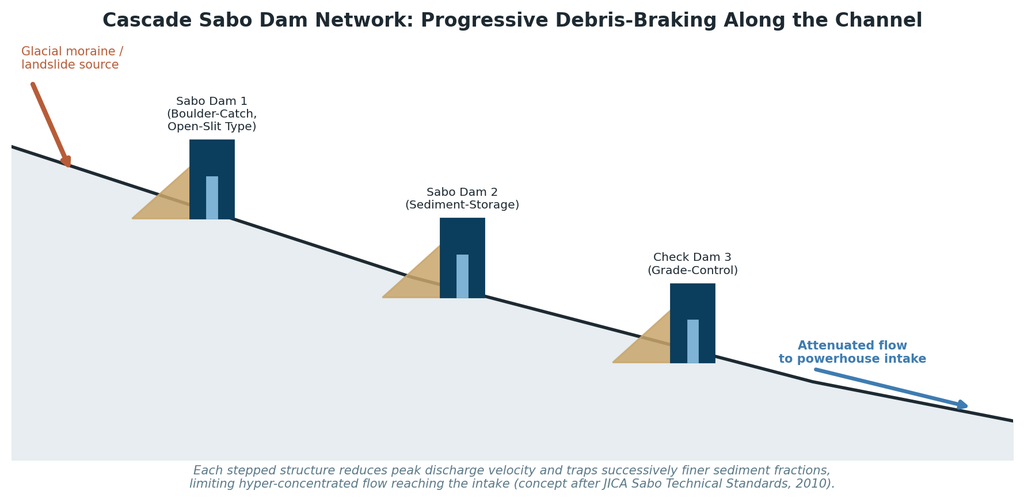
Figure 5. A cascade Sabo dam network progressively brakes debris-flow velocity and traps coarse sediment before it reaches the intake, reducing the hyper-concentrated load a headworks structure must otherwise absorb.
Field-validated case studies from volcanic and glacial catchments elsewhere in Asia confirm that beam-type and slit-type Sabo dams retain debris materials effectively, though retention efficiency declines on steeper channel gradients – precisely the condition found in most Himalayan headwater reaches – meaning Nepal’s terrain will typically require more closely spaced, lower-height structures than lowland applications. [17,18,19]
4.2 Redesigning Headworks: Dynamic Bypass Gates and Subterranean Sealing
- Dynamic sediment-slushing bypass gates that open automatically once inflow sediment concentration or turbidity crosses a pre-set threshold, diverting hyper-concentrated flow around the intake rather than through it.
- Watertight, remotely operable bulkhead gates at tunnel portals and surge-shaft heads capable of sealing the underground powerhouse from a rapid inundation event within minutes, rather than relying on manual closure.
- Redundant, above-flood-level emergency egress shafts for every underground powerhouse and access tunnel, sized and positioned independently of the main headrace alignment.
- Shift toward fully remote and automated powerhouse operation during flood-season high-risk windows, removing the need for personnel to remain underground – a measure explicitly called for by NEA leadership after the 2026 disaster.
- Real-time acoustic and turbidity sensors in desilting basins feeding automated shutdown protocols before hydro-abrasive concentrations reach turbine-damaging thresholds.
4.3 Climate-Stress Testing: Upgrading Design Floods (PMF) using Cryospheric Warming Scenarios
ICIMOD’s landmark Hindu Kush Himalaya cryosphere assessments provide the empirical basis for revising design-flood inputs. Its 2023 HI-WISE report found that HKH glaciers could lose up to 80 percent of their current volume by 2100 under high-emission scenarios, while limiting warming to 1.5°C could hold losses closer to 30 percent – a difference with direct implications for how much meltwater, and how much destabilised moraine sediment, future infrastructure must be designed to withstand. A follow-up HKH Glacier Outlook released in 2026 found that glacier mass loss across thirty-eight monitored sites had accelerated by roughly 65 percent in the 2011–2020 decade compared with the decade before, with the authors warning that parts of the Himalayan cryosphere may be approaching irreversible tipping points. [12,13]
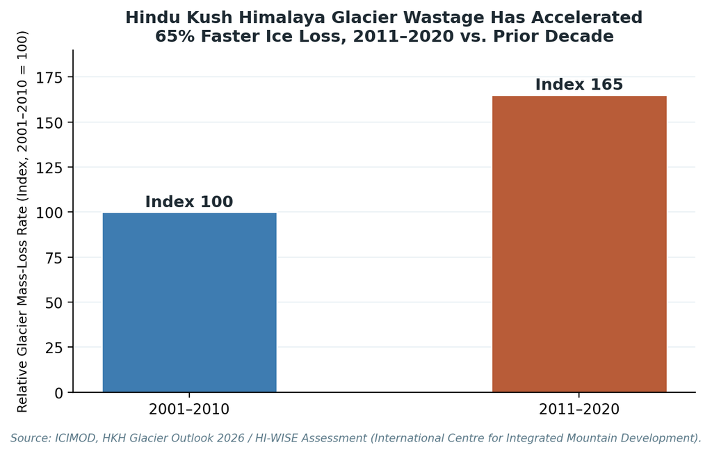
Figure 6. Hindu Kush Himalaya glacier mass-loss rates accelerated by approximately 65 percent from the 2001–2010 decade to 2011–2020, a trend with direct implications for downstream flood and sediment-supply design assumptions. Source: ICIMOD.
Translating that trend into engineering practice means Probable Maximum Flood (PMF) and design-basis sediment-yield calculations for Himalayan hydropower can no longer rely solely on twentieth-century hydrological baselines. ICIMOD and regional partners have begun piloting climate-adjusted hydrological modelling that incorporates projected glacier retreat, permafrost thaw, and glacial-lake inventories directly into basin-scale flood and sediment forecasts – an approach this paper recommends be made mandatory for licensing any new RoR project above a defined elevation or glacial-influence threshold in the HKH region.
5. Strategic Policy & Investment Reforms
5.1 Integrating Environmental Carrying Capacity into Hydropower Licensing
The Trishuli corridor’s cascade of a dozen-plus projects packed into a single glacially fed valley illustrates a licensing failure as much as an engineering one: cumulative catchment risk was never assessed as a system, only project by project. A carrying-capacity approach would require basin-wide cumulative hazard assessment – accounting for GLOF susceptibility, moraine-dam stability, and total installed capacity exposed per kilometre of river corridor – before additional licences are issued in already-saturated valleys, alongside mandatory buffer spacing between critical infrastructure and known debris-flow or outburst-flood pathways.
5.2 Insurance Frameworks and Climate Risk Pricing for Mountain Infrastructure
The scale of uninsured or under-insured loss revealed by the 2026 disaster – with independent power producers facing potential non-performing loans against washed-away assets – points to a need for parametric climate-risk insurance products tailored to high-altitude hydropower, similar to catastrophe-bond and parametric flood-insurance instruments already used for coastal and seismic risk elsewhere. Risk-based insurance pricing, tied to a project’s basin-specific glacial and sediment-hazard profile, would also create a market incentive for developers to adopt Cryosphere-Resilient Energy Engineering measures voluntarily, ahead of regulatory mandates, in order to secure more favourable premiums.
5.3 Conclusion: Building Disaster Resilience Directly into Energy Policy
The Bhote Koshi–Trishuli disaster of August 2026 should be read not as an aberration but as an early, severe expression of a risk trajectory that ICIMOD and other cryosphere researchers have been documenting for years: an accelerating Himalayan cryosphere producing floods, sediment surges, and outburst events that outpace the design assumptions embedded in existing hydropower infrastructure. Closing that gap requires simultaneous action on three fronts – structural retrofitting of existing plants with Sabo cascades, dynamic bypass gates, and hardened powerhouse egress; climate-adjusted design-flood and sediment standards for all new licensing; and financial instruments that price cryospheric risk transparently rather than treating it as an unpriced externality. Energy security in the Hindu Kush Himalaya will depend, in the coming decades, on how quickly the region’s engineering and policy institutions can make that shift.
References
[1] Ministry of Foreign Affairs, Nepal. “Daily Situation Update on Bhote Koshi River Floods” (multiple dates, 27 Aug–8 Sept 2026). mofa.gov.np.
[2] The Kathmandu Post. “Major flood damages Syabrubesi hydropower projects in Rasuwa.” 26 August 2026.
[3] Wikipedia contributors. “2026 Nepal floods” and “2026 Nepal–Tibet floods.” Wikipedia, The Free Encyclopedia. Accessed September 2026.
[4] New Spotlight Magazine. “Bhotekoshi Flood: Blow to Hydropower Sector.” 7 September 2026.
[5] Nepal News (English). “Bhote Koshi floods: Death toll reaches 903, more than 4,200 still missing.” 1 September 2026.
[6] ABC News (Australia). “Nepal estimates reconstruction after deadly floods to cost nearly $7 billion.” 12 September 2026.
[7] The Kathmandu Post. “Flood damage to Nepal’s hydropower sector could run into billions.” 30 August 2026.
[8] Bloomberg. “Satellite Images Show How Nepal Floods Damaged Homes, Power Plants, Bridges.” September 2026.
[9] Sentinel Assam / The Hans India. “Nepal’s Post-Flood Rebuild to Cost NPR 723 Billion as Damage to Infrastructure, Energy Sector Laid Bare.” September 2026, citing the Rapid Damage and Needs Assessment (RDNA), National Planning Commission and NDRRMA.
[10] Peoples’ Review. “Flood damages 13 hydropower projects worth about Rs 150 billion.” 1 September 2026.
[11] Mongabay. “Nepal’s flood disaster puts its hydropower-first strategy, exports to the test.” September 2026.
[12] International Centre for Integrated Mountain Development (ICIMOD). Water, Ice, Society, and Ecosystems in the Hindu Kush Himalaya (HI-WISE). Kathmandu: ICIMOD, 2023.
[13] ICIMOD. “Hindu Kush Himalaya glaciers losing ice at double the rate since 2000, new ICIMOD report confirms.” HKH Glacier Outlook 2026. icimod.org.
[14] ICIMOD Blog. “Developing climate resilient hydropower in the HKH.” 2025.
[15] International Hydropower Association. “Sediment Management Case Study: Nepal – Jhimruk.” hydropower.org.
[16] Various authors. “Analysis of sediment abrasion potential in hydro turbines by studying fine sediments from the Budhi Gandaki–Trishuli River of Nepal.” ResearchGate.
[17] Designing conduit sabo dam series as a debris flow protection structure. E3S Web of Conferences, 2021, citing JICA Technical Standards and Guidelines for Planning and Design of Sabo Structures (2010).
[18] “Study on hydraulic characteristics of sabo dam with a flap structure for debris flow.” ScienceDirect.
[19] “Integrating engineering and non-engineering mitigation for secondary hazards at Mount Marapi: Sabo dams and irrigation intakes for debris flow control.” Geoenvironmental Disasters, Springer Nature, 2025.
[20] “Effect of concentration and size of sediments on hydro-abrasive erosion of Pelton turbine.” Academia.edu.
Note on sourcing: Casualty figures, damaged-capacity totals, and reconstruction-cost estimates for the August 2026 disaster were still being revised by Nepali authorities at the time of writing and should be treated as the most recent verified figures available as of mid-September 2026, not final totals.